Hello, welcome to Nanjing Longce surveying and Mapping Technology Co., Ltd!
语言选择:  ∷
∷ 
∷ ∷ 
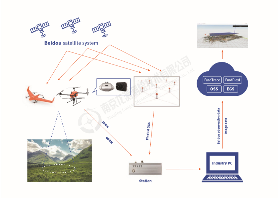
1. Realize cm-level real-time navigation and PPK calculation without base station
2. Multiple algorithms and police strategies should be used to produce different data
3. You don't need a professional team to get started quickly
4. Cloud PPK that breaks the limit of operation scope
5. Rich load supporting to meet the requirements of different projects
6. Professional service teams all over China
|
RTK services that do not require base stations More than 2000 base stations can be accessed throughout the country |
7*24 hours uninterrupted high availability broadcast |
| Automatically writes EXIF's synchronous shutter | Maximum accuracy: 2 cm |
| No need to set professional parameters, the boot is available automatically | 32 province territory personal quality experience |
| Access | SDK |
| Coordinate system |
Coordinate frameWGS84,The reference epoch2005.0 BDS:B1,B2,B3 GPS:L1C,L2S,L5Q |
| Supported formats | GLONASS;GIC,G2P |
| And frequency |
(Optional)Galilieo;E1C,E5b-Q,E5a-Q (Optional)QXSS;L1C,L2S,L5Q |
| Positioning accuracy | The plane:2-5cm Elevation:4-8cm |
|
High density foundation reinforcement network nationwide and global self - built base station support High coverage, 24/7 service |
| Accuracy is not affected by the range of flight |
| PPK services on demand |
| Standard POS file output, docking various photogrammetric software |
| Visualized H5 platform cloud data processing |
| There is no need to set up a benchmark station and purchase commercial computing software, which can greatly improve the efficiency of use |
| Calculating way | Network online solution, fixed solution rate 99% |
| The required data | Original GNSS observation data at the aircraft end;Camera exposure point Mrk data |
| Calculating speed | Take a GNSS observation data with a sampling rate of 5Hz and a sampling duration of 15 minutes as an example, and it takes about 3 minutes for the solution of the chihiro cloud trace |
| Supported aircraft type | Qian XunyiQ10;Qian XunyiX5;In continuous update |
| GNSS board card model supported |
Novatel-OEM6; Unicorecomm-UB4BO; Unicorecomm-UB482; Novatel-OEM7; Trimble-BD970; Trimble-BD990; |
| Supported integrated navigation system models |
Novatel-SPAN-CPT; Novatel-iIMU-FSAS; Novatel-ISA-100C; Novatel-SPAN-IGM-Al Novatel-SPAN-KVH1750; XW-GI7660 |
| High extension | High controllable |
|
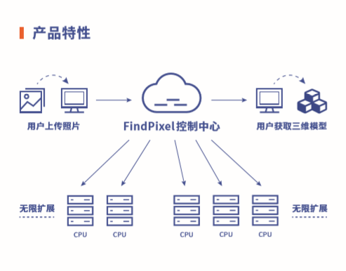
Based on ali Cloud's top computing power, it can automatically expand and schedule nodes according to the size of the project. Achieve the most efficient input and output. |
Accurate control of various parameters to ensure the output of a variety of high-quality data results |
| High efficiency | High controllable |
| The operation optimization of multi-engine strategy and the collaborative heterogeneous calculation between CPU and GPU not only make full use of the high-precision adjustment calculation ability of CPU, but also make full use of the efficient texture mapping and other capabilities of GPU. | From data import to product download, only users can view, use, download and delete the original data, intermediate results, final results and projects. In addition to the computer automatically doing some necessary statistical work, even the internal personnel on the platform have no right to browse and manage the substantive data and achievements of users. |
| Professional | Cross-Platform |
| The platform is specially designed for draft testing, with the same level of priority given to plane elevation, which can produce surveying and mapping results in line with the requirements of professional aerial surveying (including tilt photography). | The HTML5-based terminal page supports the user operation of the whole platform, Windows, Linux, ios, Android and other operating systems, including PC, PDA, Mobile and other terminals so that you can monitor and control the execution of tasks anytime and anywhere. |
| Highly reliable | Project-Driven |
| Multiple adaptive processing modes ensure high success rate and high quality of data processing;Real-time heartbeat detection and automatic task scheduling and redistribution, single node task timeout can be assigned to other nodes to execute again, and every subtask can be executed and return the correct mapping results. | The project-oriented interface simplifies the professional operation setting, and the self-adaptive parameter setting enables the operation efficiency to reach the optimal level, and significantly reduces the professional requirements and learning costs for the operators. |
| Hardware and software environment |
Ali cloud infinite node computing capability Elastic cluster operation mode |
| Data processing function |
High precision 3D reconstruction High precision orthophoto Rapid puzzle |
| Data outcome type |
3D model: OSGB/ OBJ
Point cloud: LAS/LAZ (not open yet) Digital surface model: GeoTiff/Kmz Digital elevation model: GeoTiff/Kmz Digital orthophoto map: GeoTiff/Kmz |
 Sweep WeChat yards pay attention to us

Quotation and presentation requestliuchunlei@longce.net

The mobile phone+86 13851969931
Nanjing Longce Measurement Technology Co., Ltd Address:No.15 Xinghuo Road, Jiangbei new district, Nanjing,China. ICP:苏ICP备20044645号-1