An overview of the software
InfiPoints is a powerful point cloud data processing platform with features of big data, one-stop, automatic and cross-platform processing. InfiPoints can provide flexible and diversified point cloud data preprocessing methods, automatically extract geometric features and generate THREE-DIMENSIONAL models more quickly, so as to meet users' engineering requirements for model comparison and interference analysis.3d scanning technology obtains a large number of 3D spatial data, you can be placed in the real environment to browse the overall enterprise or factory layout, management.
Main Features:
1. One-stop point cloud platform
Users can do all the processing on the same platform without using multiple tools
2. Unlimited data size
-- Innovative data indexing method, which enables video memory to quickly invoke physical memory data, InfiPoints can handle unlimited point cloud data under the premise of high enough hardware configuration
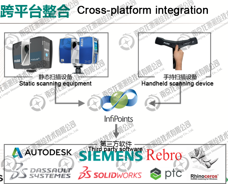
Supporting scanning equipment:
Support market mainstream scanners such as FARO, Lecia, Z+F, etc
Main functions:
1. Point cloud splicing (automatic identification of target ball splicing, automatic splicing using overlapping surfaces, target-free intelligent fitting splicing, etc.)
2. Denoising (removing moving noise points such as moving vehicles, sparse noise points, overlapping noise points, remote noise points, etc.)
3. Measure and browse (measure and browse in any direction and Angle.Can import design model to any location for mixed measurement)
4. Automatic extraction of models (the plane and pipeline models of building equipment can be extracted automatically within a few minutes)
5. Automatic extraction of the ground, can filter out trees and buildings, etc. to extract only ground point clouds.
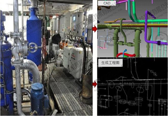
6. Export engineering drawing (can intercept any section to draw engineering drawing, and can export DWG engineering drawing to Auto CAD)
7. Assembly inspection, importing a variety of CAD models and point clouds for mixed assembly inspection
8. Extract the grid model.Polygon mesh model was extracted for complex trees and buildings.
9. Make roaming videos and make roaming videos along any path
10. Generate hd orthophoto map
11. Export executable point cloud browse file and open without any license.
Function is introduced
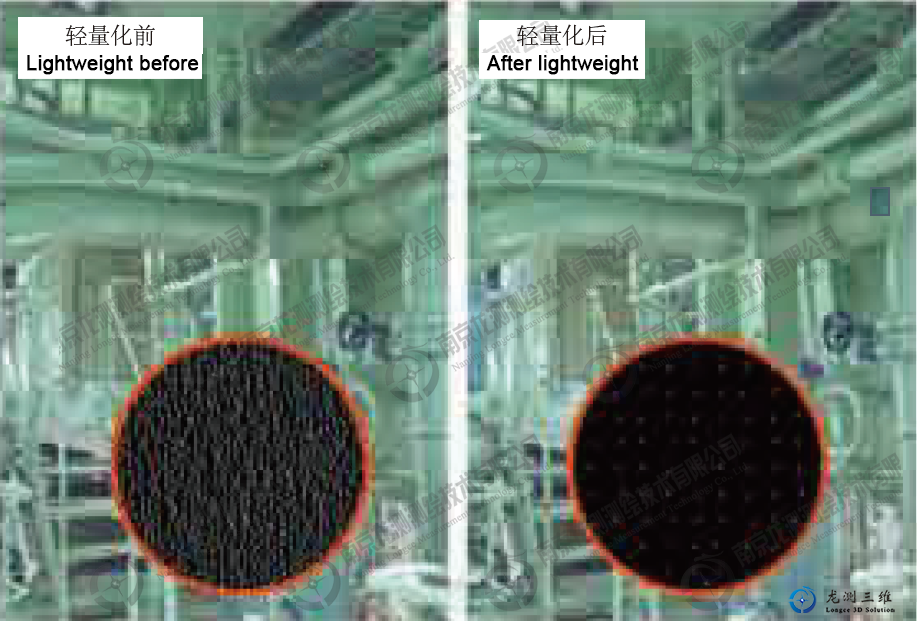
Point cloud lightweight technology
Infipoints reduces the density of the point cloud by specifying the intervals between points, thereby reducing the size of the data.This point cloud lightweight technology does not sacrifice the precision and visual effects of point cloud data.
For example, with the threshold value of 10mm, point cloud density can be reduced by 95%.
210 million points / 60GB 1000 points/ 290MB
Data splicing
Infipoints can use geometry to automatically identify the relative position of point clouds, so as to realize the automatic splicing of target-free clouds.This technology can greatly reduce the workload of field scanning.At the same time, Infipoints can also read the reference points obtained by total station as the coordinate system of point cloud data.
Automatic denoising
Infipoints can automatically identify and remove overlapping noise points from several stations of the 3D scanning point cloud.And can automatically remove moving noise from the environment, such as people or cars, etc.
Measuring the size
Infipoints can be used to measure the distance between any two points, as well as the distance and Angle dimensions between the plane and cylinder extracted.This feature enables users to survey data efficiently and accurately.
Point cloud data editing
Infipoints can be used to manage point clouds through layers, which can be used to hide unwanted points or highlight specific point clouds.Infipoints can also be used to extract points from the point cloud as groups for things like simulation of device transport paths, changes to device layouts, and so on.
Create a grid
Infipoints can automatically generate a grid for modeling from the point cloud and can be exported in STL,VRM, or OBJ formats.The derived grid data can be used as a reference in other CAD systems and can be converted into b-REPS geometry for equipment modification or other purposes.
Comparison of point clouds and CAD models
Infipoints can be used to compare the difference between CAD models of measured point clouds and conceptual designs.This scheme can also be used to compare post-construction buildings with the original design, allowing the difference between design and actual construction to be tracked at any time.
Interference checking
Infipoints automatically checks for interference with imported CAD models and point cloud data.Real-time interference checking can quickly discover problems with CAD models in point clouds.It can improve the efficiency of transportation path planning and equipment layout and simplify their working methods.In addition, multiple CAD models can be implemented to simultaneously move and check the collision interference with the point cloud according to different design paths.
Rapid automated pipeline modeling
Infipoints allows you to create 3D pipe models from point cloud data.It automatically extracts pipe shapes, bends, and flanges and replaces them with standard parts.When scanning for blind areas, it can also automatically compensate for these areas with low density point clouds.The user can also add the pipe line manually.The modeled piping system can be output in different CAD formats or axial profiles.
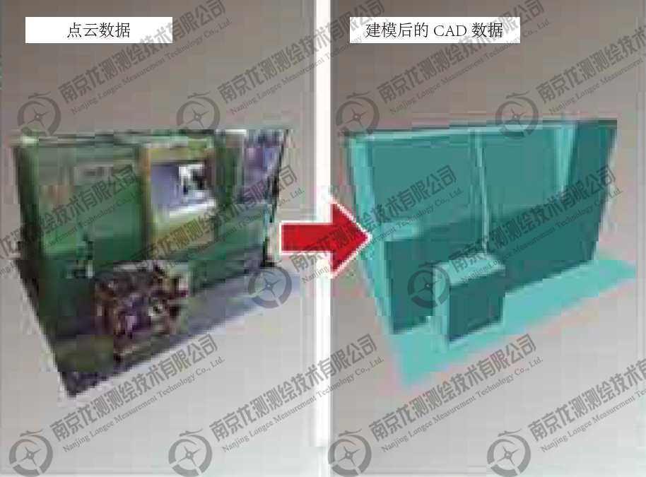
Equipment modeling
Infipoints allows you to automatically create CAD models of existing devices based on point cloud data, and it can move independently of the point cloud.It can be used to plan the moving path of the equipment to see if the equipment to be moved is in collision with walls or other equipment.At the same time, it can directly model the equipment without field mapping.
Extraction of standard structural steel
InfiPoints supports the identification and creation of structural steel models, such as H, I, T, etc., which can be exported to BIM software for subsequent development and design.
Export achievement
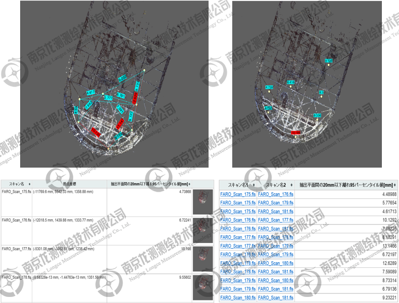
Professional splicing report
Infipoints is able to view the data Mosaic results in detail and view the detailed data Mosaic results through color difference graphs, data histograms, reports and so on.Infipoints can also export the splicing report, quantify the splicing results, and facilitate users to submit the splicing data results.
Create a roaming video
Users can easily create high-quality roaming video from point cloud data with unlimited data size.The generated video can capture CAD model and point cloud data at the same time, effectively displaying the expected design results.The accuracy of project planning and cost estimation can be significantly improved, and project members located in different geographical locations can work together in different places.
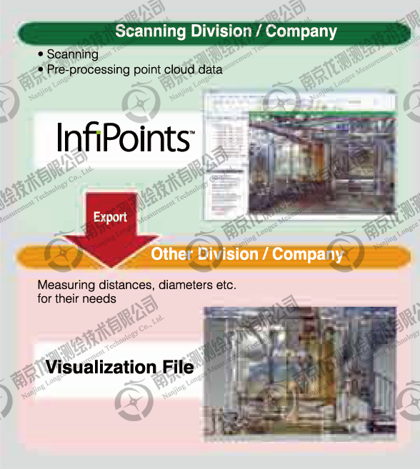
Export visualization file
Infipoints provides the ability to package and export visual files that can be sent individually to customers who do not need to install Infipoints to easily measure, analyze, or create sections on 3D data.
Derived orthogonal image
InfiPoints enables the export of orthogonal images with high resolution at specified locations.Users can add grid lines to the exported orthogonal images, and can set the number of pixels, image size (height/width), and so on.The exported image data can be used in many situations, such as printing images for field measurements or importing them into other tools for creating trace drawings.
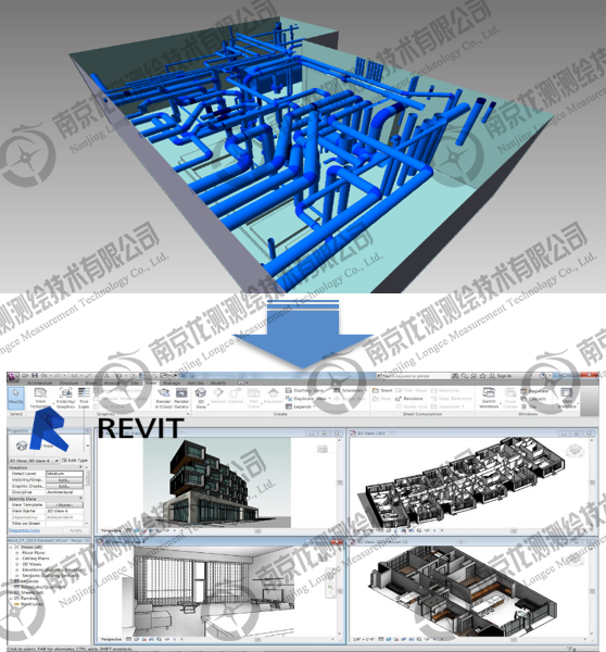
Export to CAD models into BIM software
InfiPoints supports exporting THE GENERAL intermediate format IDENTIFIED by BIM software in IFC format, which can transfer CAD models such as pipes, equipment and structural steel into BIM tools and simplify the workflow of BIM data reconstruction
Configuration requirements
Since processing a large amount of point cloud data requires a high level of hardware configuration, the following are recommended hardware configuration standards when installing Infipoints, which have achieved satisfactory results for users, although Infipoints has been extensively optimized for data processing.
|
Machine/CPU
|
System configuration requirements
|
|
Memory
|
8GB or more
|
|
OS
|
Windows 7 Professional 64-bit SP1
|
|
Windows 8 Pro 64-bit
|
|
Disk Device
|
20GB or more, SSD is recommended
|
|
Graphic
|
Graphic card supporting OpenGL
|
Supported scan data
Infipoints supports the widely used 3d laser scanner in the market and is compatible with a wide variety of scan data.
*1 ENF: Elysium intermediate format
CAD data Input/output interface
|
Product
|
Input & output format
|
The input
|
The output
|
|
CATIA V5 Add-on
|
CATIA V5
|
●
|
●
|
|
CATIA V4 Add-on
|
CATIA V4
|
●
|
●
|
|
NX Add-on
|
NX
|
●
|
|
|
Pro/ENGINEER Add-on
|
Pro/ENGINEER
|
●
|
|
|
Parasolid Add-on
|
Parasolid
|
●
|
●
|
|
ACIS Add-on
|
ACIS
|
●
|
●
|
|
JT Add-on
|
JT
|
●
|
●
|
Rhino plugin
The Rhino plug-in is used to visualize and model point clouds in Rhinoceros.Any preprocessing done in Infipoints can be mapped into Rhino, such as denoising or layer management.It also supports the section function of Rihno, enabling users to model in the corresponding area based on point cloud.